JavaScript Framework
Build web applications with feature-rich and customisable maps, through easy class and method libraries.

Personalization
Perform run-time modifications of map styles and property settings, such as color, width, label size and zoom level.
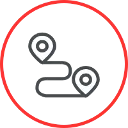
Car and Pedestrian Routing
Provide turn-by-turn instructions for driving and walking worldwide. Let users set their own preferences, such as fastest routes, as well as restrictions like tolls and highways.

Real-Time Traffic and Incidents
Add real-world context to your application by integrating real-time traffic information about accidents, congestion, construction and more.

Map Drawing and Data Display
Add multiple overlays for points, lines or areas with GeoJSON data sets.

Interactivity
Take advantage of pre-built and customisable UI elements that enable users to zoom, pan, scale, choose map type and more.

Geocoding
Turn addresses into geo-coordinates and vice versa. Get accurate matches with millions of precise addresses worldwide.

Street View Imagery
Enrich your map with up-to-date and community driven street view images.

Map and Satellite Tiles
Integrate professionally designed, pre-rendered map tiles in a variety of styles, including street, traffic and hybrid maps.

Places Information
Make it easy for users to search, explore and interact with points of interest. Access millions of named and categorised places worldwide.

Geofencing
Monitor mobile assets entering or leaving a certain geographic area. Customise the search radius around a position for triggered alerts.